GROUP CONTROLS
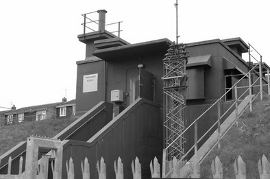
The former ROC 20 Group Control at York; now preserved by English Heritage [1]
With the development of 31 Group in Northern Ireland in 1955, 31 group controls existed; many of which were surface level buildings; and being generally developed during WW2, offered very little protection from the effects of a nuclear bomb.
At roughly the same time as the underground Monitoring Posts were being built, a number of protected Group Control Headquarters were therefore planned in order to provide a satisfactory level of protection to "survive" a nuclear attack. Although initially planned in 1956, development of these buildings did not commence until 1959 with the majority of sites becoming operational in 1960/61. These new purpose-built semi-sunk Group Control buildings were therefore developed to offer a greater level of protection over and above those previously built. These buildings consisted of a three-level reinforced concrete building which has been covered by an earth mound up to the height of the middle floor.
These controls collated all information from the Monitoring Posts within their group and aimed to establish the exact location, height and power of the nuclear explosion.
The structure of the building is as follows;
- Top Level: Entrance to the building is via a flight of steps which leads up to the top floor and unprotected level of the building. This top level, being above the protection of the earth banking is constructed with thicker walls to withstand the greater impact of a nuclear blast. The top level contains the initial airlock and decontamination room to restrict any access of nuclear fallout into the building. Also in the top level is the water tank which would provide enough water for at least two weeks supply, during an emergency situation.
- Middle Level: The middle floor contains the main residential area of the building, including; toilets, male and female dormitories, officers room as well as plant room, ejector room for sewerage, telephone frame room, kitchen and rest rooms. Also on this floor is the top level of the plotting room, which provides access onto the balcony where all the burst and fallout information from the posts was collated. Burst times, pressure reading, bearings and elevations were plotted on the triangulation table and fallout readings were plotted on tote boards. In groups equipped with “AWDREY”, the computer was located near to the triangulation table on this level.
- Bottom Level: The bottom floor contains the main communications for the control including switchboard, warning keyboard, ‘Display for Europe’ and the fallout decay plotting boards. The bottom floor also incorporates the plotting area which provides access to the Displays A and B for assessing the impact and path of nuclear fallout across the country and contains the working area for the UKWMO Warning Officers who provided the scientific advice.
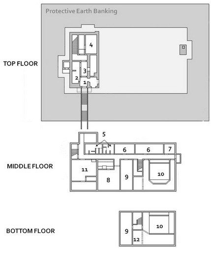
Plan of ROC Group Control showing main key operational rooms [2]
 Rotating Tote Boards [3] |
 A’ & ‘B’ Plotting Boards [4] |
Since the mid 1950's the number of group controls steadily reduced from 31 during the mid 1950's to 29 during the 1960's to 27 during the 1970's and finally ending with 25 Group controls by initial stand-down in 1991. The PDF file below lists the locations of Group Controls since 1955 whilst a map of the Group Controls circa 1991 may be found HERE.
| Group Control Locations.pdf |
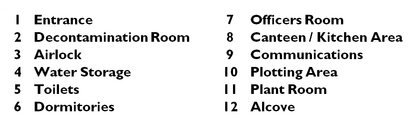
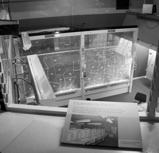
GROUP CONTROL IN ACTION
The pictures below show the Group Control for 23 Group - Durham circa 1990 during operations. (5)
Image Sources:
[1] Noel Ryan, AiX / ARG
[2] Manual representation of plans by Cocroft & Thomas, 2004
[3] & [4] Chris Howells www.chrishowells.co.uk
[5] Images copyright - Olive Perrin. Images must not be reproduced without permission of copyright owner.